

Free delivery for purchases over 59.99 €
Slovak post 4.49 €
SPS courier 4.99 €
GLS courier 3.99 €
GLS point 2.99 €
Packeta courier 4.99 €
Packeta point 2.99 €
SPS Parcel Shop 2.99 €
 How to shop
Help
Delivery
Slovak post 4.49 €
SPS courier 4.99 €
GLS courier 3.99 €
GLS point 2.99 €
Packeta courier 4.99 €
Packeta point 2.99 €
SPS Parcel Shop 2.99 €
Free delivery for purchases over 59.99 €
Shopping guide
We’re here for you!
02/210 210 99
My account
Become part of a community of book lovers from all over the world and get access to a whole bunch of benefits.
Create an account for free
▸
Empty :-(
0
Britain And Ireland Executive Laminated Map
Language
 English
English
Printed items
Map
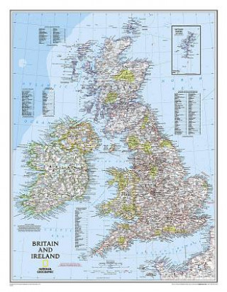
Our classic political map of Britain and Ireland shows country boundaries, thousands of place names,...
Full description
Libristo code: 04703594
?
 87 b
87 b
87 b
34.87
€
50 % chance
We search the world
When will I receive my book?
30-day return policy
You might also be interested in


Our classic political map of Britain and Ireland shows country boundaries, thousands of place names, major highways and roads, airports, bodies of water, and more. Map is printed on premium quality paper stock, laminated, rolled, and packaged in a clear plastic sleeve."Map Scale = 1:1,687,000Sheet Size = 23.5" x 30.25""
About the book
Full name
Britain And Ireland Executive Laminated Map
Author
National Geographic Maps
Language
English
English
Binding
Printed items - Map
Date of issue
2012
Number of pages
1
EAN
9780792250234
ISBN
0792250230
Libristo code
04703594
Publishers
National Geographic Maps
Weight
160
Dimensions
750 x 575 x 2
